
Pluto and Charon Map: Regions, Names, and New Horizons

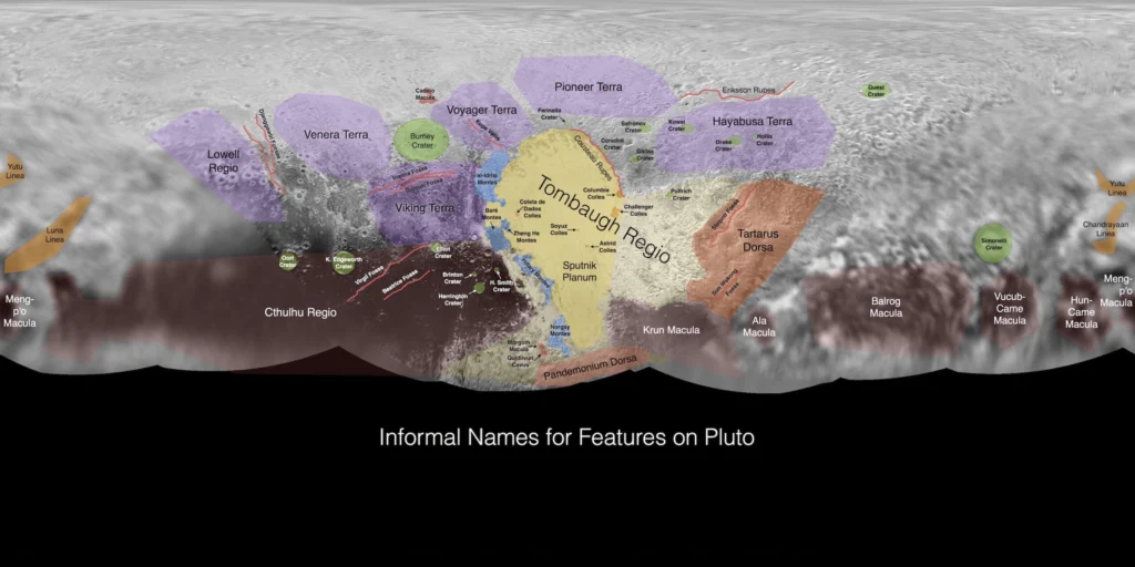
NASA’s New Horizons spacecraft mapped Pluto and Charon during its July 14, 2015 flyby. Global maps combine LORRI and MVIC images, and the IAU has approved names such as Tombaugh Regio and Sputnik Planitia on Pluto and Mordor Macula on Charon. The official names and maps are available from NASA and the USGS Gazetteer.
What does a map of Pluto and Charon show?
A map of Pluto and Charon shows a global mosaic built from New Horizons imaging, not a single photograph. Each visible patch was imaged by the Long Range Reconnaissance Imager (LORRI) and the Multispectral Visible Imaging Camera (MVIC), then stitched into one base map. The labels come from the International Astronomical Union (IAU) Gazetteer, which records approved feature names. On Pluto the map highlights bright plains, dark equatorial regions, and ridges, while Charon shows a dark north pole and a fractured equatorial belt. The named features are what turn a raw image into a readable Pluto and Charon map. The body itself is a dwarf planet, a status explored in why Pluto is classified as a dwarf planet.
How New Horizons made the maps
New Horizons flew past Pluto on July 14, 2015. Its closest approach brought the spacecraft about 12,500 km (7,800 mi) from Pluto and about 28,800 km (17,900 mi) from Charon, according to the New Horizons mission site at APL. Approach imaging had already begun in the preceding weeks, but the closest images produced the highest-resolution strips used in the global mosaic. The science camera LORRI provided fine detail and MVIC added color; teams then matched the images to a common coordinate grid. How New Horizons reached Pluto is covered in the mission timeline.
Pluto map with feature names: named regions on Pluto
The IAU has approved names for many regions on Pluto. Four features are useful anchors when reading a labeled Pluto map. In the Gazetteer, a regio is a broad region, a planitia is a plain, a macula is a dark spot, and dorsa are ridges. Pluto’s nitrogen-ice surface is especially clear in Sputnik Planitia.
| Name | Feature type | Why it stands out |
|---|---|---|
| Tombaugh Regio | Regio | Bright, heart-shaped region that dominates the encounter hemisphere. It honors Clyde Tombaugh, who discovered Pluto in 1930. |
| Sputnik Planitia | Planitia | Nitrogen-ice plain inside Tombaugh Regio; the bright western lobe of the heart. |
| Cthulhu Macula | Macula | Dark equatorial belt visible on the encounter side. |
| Tartarus Dorsa | Dorsa | Rugged ridge terrain near the eastern edge of Tombaugh Regio. |
Named features on Charon
Charon has a smaller set of IAU-approved names, but three landmarks are useful for map reading. Mordor Macula is the dark reddish patch at the north pole. Vulcan Planum is a broad plain visible in global maps, and Serenity Chasma is a fracture feature crossing the equatorial region. The names and types appear in the Gazetteer and in an atlas of the outer worlds.
| Name | Feature type | Map appearance |
|---|---|---|
| Mordor Macula | Macula | Dark reddish north-polar area thought to contain processed organic material. |
| Vulcan Planum | Planum | Broad plain visible in global maps. |
| Serenity Chasma | Chasma | Equatorial fracture feature. |
Pluto vs. Charon: key map facts
Pluto and Charon form a binary system, but they look different at map scale. The diameters below come from NASA's Pluto overview.
| Body | Diameter | New Horizons closest approach |
|---|---|---|
| Pluto | 2,377 km (1,477 mi) | 12,500 km (7,800 mi) |
| Charon | 1,212 km (753 mi) | 28,800 km (17,900 mi) |
Charon is just over half Pluto's diameter. For context on its orbit and companions, see Pluto’s satellite system, and for the material behind the terrain, see what Pluto is made of.
Where to view the official maps
The most reliable sources for labeled maps are official ones.
- NASA's Pluto pages show the global mosaic and mission imagery.
- The USGS Gazetteer of Planetary Nomenclature lists IAU-approved feature names and types.
- The New Horizons mission site at APL provides instrument and encounter details.
- The IAU explains the naming process and approvals.
What remains poorly mapped
Only one spacecraft has mapped Pluto and Charon at close range. New Horizons returned detailed views of the encounter hemisphere, but the south polar regions and much of the opposite hemisphere were seen at lower resolution or in twilight. The July 2015 flyby was a single pass, not an orbiter, so coverage could not be repeated. The global map is therefore uneven in detail.
Frequently asked questions
Why is Pluto’s bright heart called Tombaugh Regio?
It honors Clyde Tombaugh, who discovered Pluto in 1930; the IAU approved the name.
What is the dark red region on Charon?
Mordor Macula, a dark reddish north-polar area thought to contain processed organic material.
Where can I view a labeled Pluto and Charon map?
In the NASA Pluto pages, the USGS Gazetteer of Planetary Nomenclature, and the New Horizons mission site.
When did New Horizons map Pluto and Charon?
During the July 14, 2015 flyby, with approach imaging in the preceding weeks.
Sources
Keep reading